Like many industries, technology is changing agriculture in America. Precision agriculture uses new tech to observe and measure farm field data, and one of the most useful tools is proving to be drones. Researchers at the University of Maryland in the College of Agriculture and Natural Resources and University of Maryland Extension (UME) are using drones to help farmers and growers enhance their integrated pest management plans (IPM), learn about programming, and gather aerial data on crops and wildlife.
Prepare for takeoff – Part 107
To start building out a future workforce of agriculture professionals equipped with this technology, Tom Mazzone, a lecturer for IAA at UMD, teaches a GPS and Drone Applications course. Students learn to fly drones and prepare for a Federal Aviation Administration (FAA) test called Part 107, which is required for those who want to fly drones for commercial purposes.
Mazzone said that growers also need guided education for taking the test and to understand the software that comes along with being a drone pilot.
“If you don’t have basic programming knowledge, you are going to be lost, and a lot of farmers are going to need an instruction manual or an all-in-one solution for using drone technology,” Mazzone said.
Because College Park falls under the FAA no fly-zone, researchers utilize the Maryland Agricultural Experiment Station (MAES) Research and Education Centers (RECs) for flights. Mazzone takes his class to the Central Maryland REC (CMREC) Clarksville facility where the drone program was born from the ideas of the late Stanton Gill, a visionary in Extension programming.
“Drones have so many applications and possibilities for the commercial horticulture industry in Maryland,” said Gill. “We’re trying to move the industry forward with this technology.”
Aerial Research
Scientists at the RECs are putting drones to work in their research projects to carry out activities like inventory management and assessing water stress in crops.
Andrew Ristvey, Extension specialist in commercial horticulture, helps nurseries and Maryland growers utilize drones as part of their operations.
To measure water stress in a plant using drones, a pilot must select the sensor best suited for their needs. For example, multi-spectral cameras take images with four different wavelengths: red, green, infrared and near infrared. This type of sensor can be used to measure normalized difference vegetation index (NDVI)—a visual indicator for plant health.
Ristvey also utilizes thermal imaging to help with data collection. A thermal imagery drone determines the water stress by looking at transpiration levels on leaves.
“So, a leaf would appear cool if the plant is healthy and transpiring water. But if it’s not transpiring water, which means it is in water stress, the leaf gets hot,” said Ristvey. “And, you can clearly see that using thermal imaging.”
Ristvey also used thermal imagery to mark areas with irrigation problems. “We flew a drone over fall chrysanthemums in a big nursery with drip irrigation. If one of the drips isn’t working, that plant is going to go into water stress,” Ristvey said.
The thermal camera was able to detect areas where the drip irrigation slipped out. In addition to saving crops, drones have the potential to save growers time and labor on solving these issues.
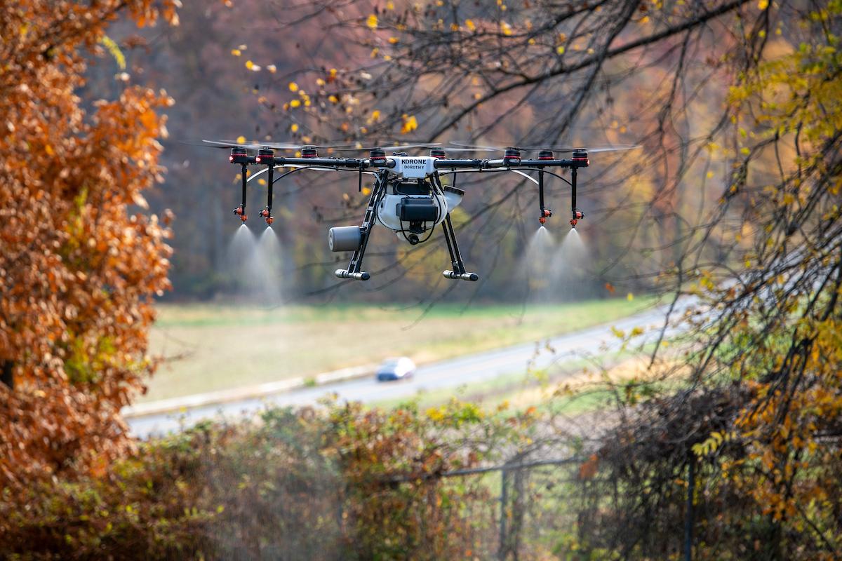
David Clement, Extension specialist in plant pathology, focuses on using drones as a diagnostic tool to better understand and identify plant diseases. He said a large goal of using drones for pesticide application is that it requires less product.
“The overall goal is to have more precision agriculture so we can target problems with the least amount of chemicals and develop an early diagnosis,” said Clement. “We can treat what we need to treat without having to spray an entire field.”
Software and Programming
Hemendra Kumar, Extension specialist in precision agriculture, provides programming solutions for fellow researchers and Maryland growers at his Precision Agriculture Lab located at the CMREC Upper Marlboro Facility. He and his team develop deep learning artificial intelligence (AI) algorithms for drone software to predict the water and nutrient stress in row crops.
Using grain crops like corn and soybeans as subjects, Kumar tests a variety of irrigation rates. He flies drones over the plots and gathers field data from soil moisture sensors in the ground. The culmination of data is collected, analyzed, and placed into an algorithm that helps increase the accuracy of drone data, which can be used in crop modeling.
Kumar described camera drones as a "hawk’s eye" for farming, capable of swiftly scanning both small plots and large farms, much faster than humans. Like a hawk’s sharp vision spotting the smallest details from great heights, drones can detect subtle crop health anomalies invisible to the human eye.
“We are looking to solve the problems in the agriculture, horticulture, and in the ornamental community,” Kumar said. “We want to make agriculture production more efficient, reduce labor time, and increase the use of sustainable practices with the help of new ag technologies.”
Weed Management
Drone data accuracy is vital when delivering precision solutions. Kurt Vollmer, Extension specialist in weed management, uses drones to survey weeds among his plots at the Wye REC.
Primarily using drones for crop scouting, Vollmer said it does not require a large, sophisticated drone—a small one with the right type of camera is accessible and efficient.
“It lets me see stuff that I never really thought of and gives me a better perspective,” said Vollmer.
Researchers agree that increased accuracy is a large benefit for using drones in pesticide applications. Vollmer said it is not a substitute for everything that is done in a field, as farmers must still rely on cover crops or pre-emergence herbicides for weed control early in the season.
“The other advantage for using drones for spraying is it allows you to get in the field at times when larger equipment might not be able to make it—like areas with rough terrain that is difficult for equipment to navigate,” said Vollmer.
Wildlife
Drones also help researchers gain unique insights into ecosystems and habitats. Extension’s wildlife management specialist, Luke Macaulay, uses drones to gather data on bobwhite quail habitat and deer populations.
At night in the wintertime, he uses thermal cameras to quickly identify and count deer when they are often out in open fields. He merged his interest with drones with his prior experience doing GIS work, remote sensing, and satellite imagery analysis.
“I was immediately drawn to drones and realized we can document habitat composition and create excellent aerial maps at a really high-resolution,” Macaulay said.
Macaulay said drones will eventually reduce the need for manned flights for spraying and seeding.
“As capabilities increase and costs go down over coming years, I think we will see increased use of drones for both capturing high resolution aerial imagery and using them for seeding and targeted spraying practices,” said Macaulay.
Continuing his hopes for the future, he looks forward to drones being more widely used to perform targeted spot spraying of invasive plants.
“With all the challenges we are facing with fast-spreading invasives, new technologies like drones have huge potential to improve the efficiency and effectiveness of control efforts,” Macaulay said.
Researchers will continue to reshape the industry through their innovative drone solutions, paving the way for a more efficient and sustainable future in precision agriculture.